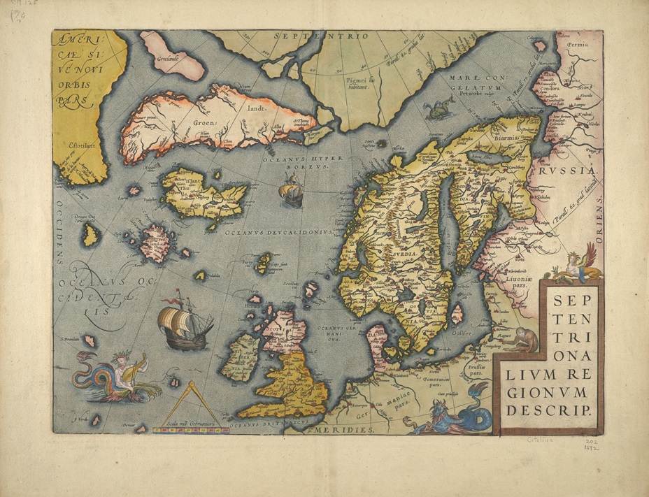
The Museum’s archives are full of wonderful and seldom seen objects that span over 500 years of maritime history. As the archivist, I derive infinite pleasure from discovering such items and making them accessible to the public. Some of my favorite discoveries have been in the collection of maps and atlases, including the map illustrated above.
This map of Northwest Europe was originally printed in the 1570 edition of Abraham Ortelius’ Theatrum orbis terrarium (Theatre of the World), which is widely considered as the first modern atlas. Between 1570 and 1612, thirty-one editions of the Theatrum orbis terrarium were printed. The Library owns a 1592 edition of the atlas, in addition to a number of separate maps by Ortelius that once graced the many editions of Theatrum orbis terrarium.
My interest in this map was sparked by an exhibit on sea monsters in maps curated for The Mariners’ Museum Library by Maria DiBenigno, an intern from the American Studies program at the College of William and Mary. While the map is geographically interesting, as it represents one of the most accurate renderings of Scandinavia and the British Isles produced in the 16th Century, it is the depictions of sea monsters and their coloration which really caught my eye.
It should be noted that most of the sea monsters depicted in early maps were derivatives of illustrations in Olaus Mangus’ 1539 map, Carta Marina, and the subsequent publication of it in his book Historia de gentibus septentrionalibus (History of the Northern Peoples, first published in 1555). The Library owns a 1561 edition of this work, which may be the topic of a future blog.
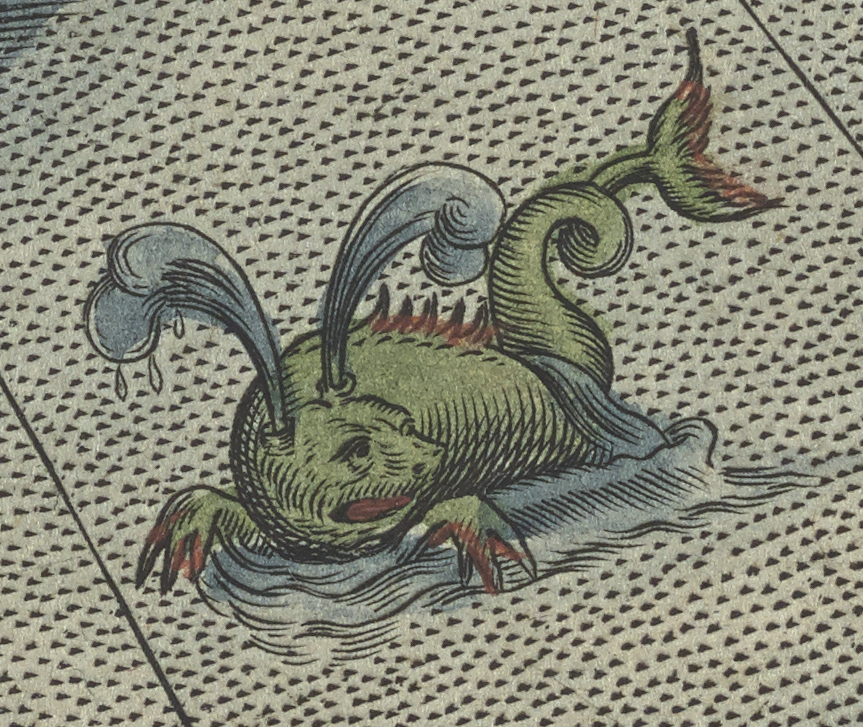
Back to the Ortelius map… In the upper right corner of the map, just above Scandinavia, is an illustration of a whale, typically called a Balena in early maps. While Magnus and Ortelius both recognized the existence of numerous types of whales, it is frequently difficult to identify the actual species being depicted. In his work on sea monsters, Joseph Nigg notes that the Balena may represent the Northern Right Whale.[1] He goes on to describe the Balena – with its “spouting blowpipes, pointed snout, teeth, ruff around the neck, pawlike flippers. ridge down its back, and cetacean fluked tail”[2] as one of the most commonly depicted whales. Sometimes it is shown menacing a ship, other times it is seen with a calf. Sometimes the whale is so large that ships anchor to it and men clamber on its back, lighting fires. Sometimes it is shown next to an orca.
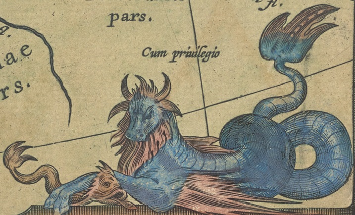
Another striking example of a sea monster is seen next to the title block in the lower right corner. Pliny the Elder (23 -79), in his Natural History, postulated that for every land creature had an equivalent creature in the sea. Early medieval mapmakers therefore populated their maps with hybrid creatures such as sea cows (and bulls), sea dogs, sea pigs, and more.[3] The image below is an excellent example of a sea bull.
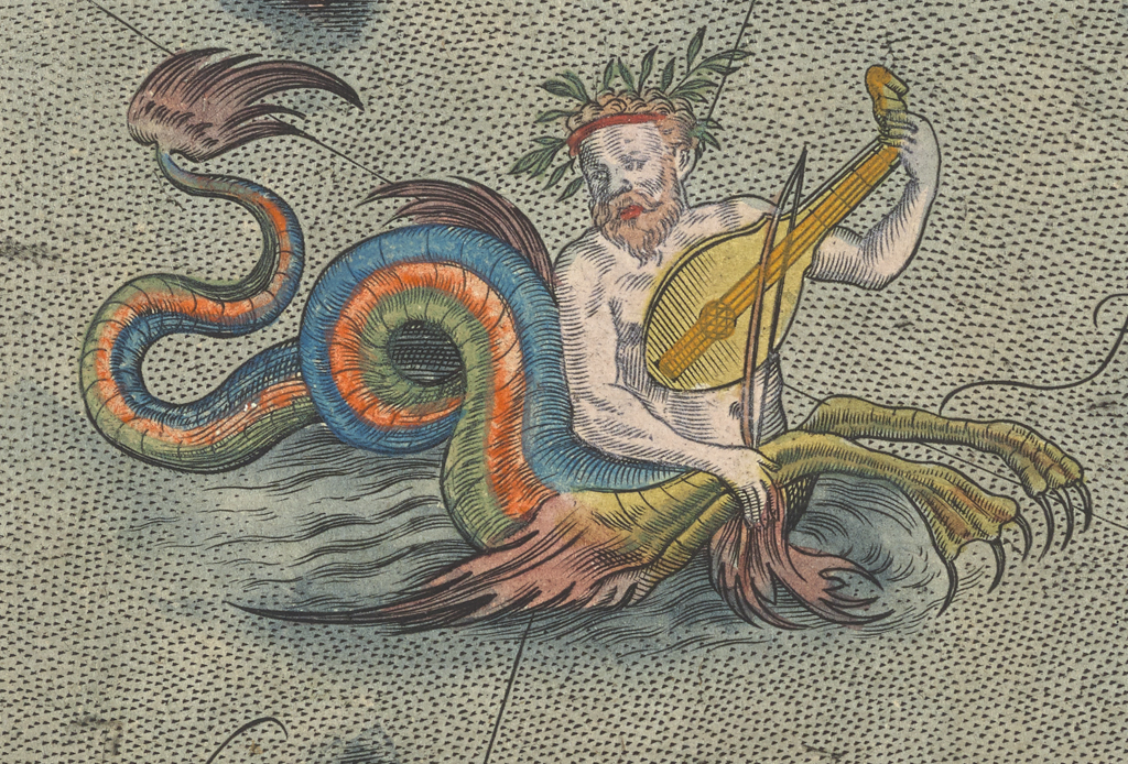
By far the most intriguing image in the map is the Ichthyocentaur depicted in the lower left corner of the map, due west of the British Isles. The ichthyocentaur has its origins in Greek mythology; it is described as a sea creature with the upper body of a man, the lower fore-quarters of a horse, and the serpentine tail of a fish. In Greek mythology, there were two ichthyocentaurs, Bythos and Aphros, brothers of the centaur Chiron.
This 17th Century depiction of an ichthyocentaur takes liberties with the description above by modifying the fore-legs of the creature. Additionally, this example is seen playing a viol. What is perhaps most striking about this illustration is the color palate used by the colorist. The colors seem to be taken from a 1960’s poster rather than a 17th century map. Chet Van Duzer, whose work on sea monsters is well known, had an opportunity to view this map when he spoke at the museum a few years ago. He stated that the colors are entirely appropriate for this map.
I hope you’ve enjoyed this look at one of the archives’ intriguing maps. Maps from the late medieval period and the Renaissance are wonders to behold. They combine new knowledge of the world with images of creatures real and imagined. As Chet Van Duzer notes in his introduction, “The subject [of sea monsters on medieval maps] is important in the history of not only cartography and of art, and specifically of zoological illustration, but also the geography of the marvelous and of Western conceptions of the ocean.”[4] I’d be happy to answer any questions about this map, and welcome your suggestions on other maps to highlight as I explore the “geography of the marvelous” in future blogs.
Suggestions for further reading:
Nigg, Joseph. Sea Monsters: A Voyage around the World’s Most Beguiling Map. Chicago; London: University of Chicago Press, 2013.
Van Duzer, Chet. Sea Monsters on Medieval and Renaissance Maps. London: The British Library, 2013.
This article from the Library of Congress gives background information on Ortelius’ Theatrum orbis terrarium: https://www.loc.gov/collections/general-maps/articles-and-essays/general-atlases/ortelius-atlas/
Footnotes:
[1] Nigg, p. 152.
[2] Nigg, p. 54
[3] Van Duzer, p. 9.
[4] Van Duzer, p. 8. emphasis added