Recently I was working on finding objects for the upcoming Gallery Crawl and I stumbled across a great drawing in our collection. I was led to it as I researched a naval officer who owned a ditty box in the collection, James Paterson McKinstry, because it reputedly showed the action McKinstry was wounded in while serving as captain of the USS Monongahela (the night David Farragut’s West Gulf Blockading Squadron attempted attempted to run past Confederate batteries on the Mississippi River at Port Hudson, Louisiana). When I looked at the image I quickly realized that something wasn’t right and after digging through the object file it almost made me cringe with embarrassment—not my own, but for past curators of not only our organization but a few others.

When acquired, the drawing was encased within a mat and backing board that bore a handwritten inscription which partially read “…drawing of the fleet before New Orleans drawn by William B. McMurtrie…”. Inscriptions can be great things, but when they are applied by someone who wasn’t directly associated with the creation of a piece they should be taken with a grain of salt. Apparently every curator who came into contact with this drawing automatically assumed that the inscription identified the scene correctly but I knew from the first moment I looked at it that something was wrong.
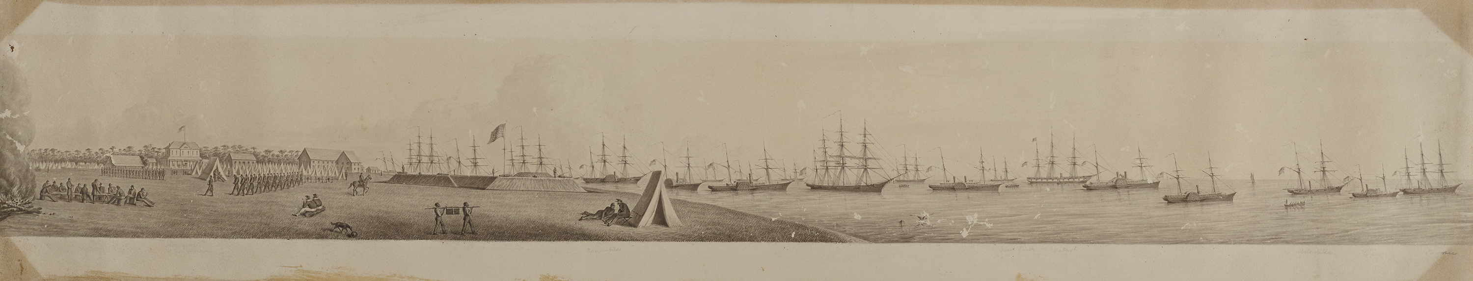
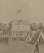
The drawing does show a very large US Fleet (with non-naval transport ships amongst them) during the Civil War but not at New Orleans, it shows Fort Walker on Hilton Head in South Carolina. While I am not expert on the Civil War or the Battle of Port Royal I do know how to look at objects and this drawing had a few dead giveaways—the most obvious of which was a faint pencil inscription under a house that said “Headquarters of Gen. Sherman”. Several of the ships were also identified: Vanderbilt, Isaac Smith, Wabash, Unadilla, Vixen and Pawnee. It looks like there were other handwritten identifications but they were apparently obliterated by conservation work performed in 1976.
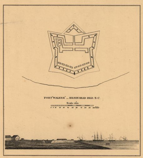
I did a little research on the artist, William B. McMurtrie, and discovered that he spent many years employed by the United States Coast Survey. I even managed to find a print titled “Plans & Views of Rebel Defences, Coast of South Carolina” that showed a nearly identical image of Fort Walker published by the Coast Survey in 1862.
To confirm my suspicions I contacted fellow staff member John V. Quarstein and asked him to take a look at the drawing. Thankfully he confirmed that the image does appear to show Fort Walker shortly after its capture by the Union during the Battle of Port Royal, November 7, 1861.
I think one of the most interesting bits of information I learned as I researched the piece was the large role the US Coast Survey played during the Civil War. In this particular instance several ships of the Coast Survey were assigned to the South Atlantic Blockading Squadron to assist with surveys supporting operations of that squadron in South Carolina waters. The ship Arago and the steamer Vixen joined the squadron and sailed only to have the fleet scattered by a storm so that most ships had to sail south independently. Vixen was first to arrive and when the fleet reassembled Arago and Vixen participated in the expedition to seize Port Royal, South Carolina. After surveys in the vicinity of Port Royal the USCS personnel continued to support blockading fleet operations with surveys and by buoying channels. McMurtrie seems to have commemorated the Coast Survey’s participation by identifying one of their ships–Vixen.