
The Mariners’ Museum Park was meticulously planned out. Early goals of the Park included a wildlife sanctuary and a tree of each species found in Virginia. Land purchases began in March of 1930 and lasted for three years until 44 parcels had been purchased, ultimately equalling over 820 acres, to make these dreams a reality. Our original Park extended from the James River shoreline to modern-day Jefferson Avenue.
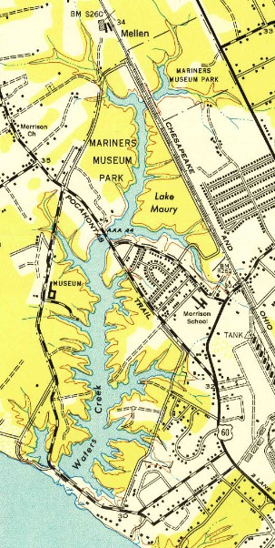
As the land purchases were completed, work began on the roads to access the Park. As you can see from the map above, all roads were on the edges of the Park except for Warwick Boulevard, then named only Route 60. Both Archer Huntington, the founder of our Museum and owner of the Newport News Shipyard, and his wife Anna Hyatt, renowned sculptor, thought to keep all roads on the exterior of the Park enhanced its beauty and created a true wildlife sanctuary.
With entrance and exit roads established, attention turned to planning the planting of the Park. In July of 1930, Charles F. Bailey, Shipyard Engineering Director and Administrative Vice President for the project of building the Museum and creating the Park, sent out an internal memo to Shipyard employees asking for anyone interested in nature. George C. Mason of the Hull Technical Division was the only one to reply. He worked on weekends to identify all plants and trees within the Park to begin a planting plan. By the end of October 1930, Mason had found 120 varieties of shrubs and trees within the Park.
In March of 1931, Mason requested to be transferred full-time to a job, ‘with forestry shrubbery, flowers, and wild bird work.’ Mason was told he would need formal training to assume such a job. In September of 1931, Mason enrolled in NC State’s newly-formed Department of Forestry program. When he graduated in the summer of 1932, he assumed the role of the Museum’s first, and only, Museum Forester.
During Mason’s time at NC State, he worked closely with Professor Ralph W. Hayes. Hayes became a Park forestry consultant for the Museum assisting Mason in creating land-use plans. In July of 1931, Professor Hayes set out to begin mapping out the Park. He separated it into 16 blocks, designated with Roman numerals. He stated that “these have been arranged largely on the basis of natural features and composition of present ground cover”. The document and accompanying map included his planting, removal, and general care suggestions.
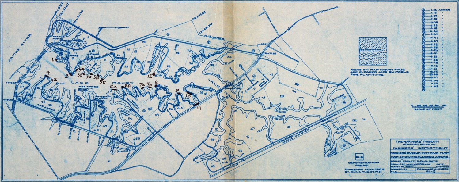
As you can see from the map above, each of the areas was carefully chosen based on land cover and use. Each of the 16 blocks was further divided into sections to provide a more detailed description and care plan. As a reference point to how meticulously the Park was planned, below is an excerpt from the map’s accompanying document:
| Block VIII |
| (51) cleaned up to give the best appearance possible |
| (52) handled in the same way 51 but save the holly and create border plantings to shut off house and outbuildings from view from the boundary road. This area is partly open and partly orchard-any desired species may be used |
| (53) leave alone and only clear out suppressed/dead pines |
| (54) thin out, leaving all good young hardwoods and removing all pines |
| (55) remove all climbers (honeysuckle), leave the good trees, and plant once the area has recovered from climbers |
| (56) interplant with individual or small group plantings to give variety and color-introduce conifers. Special attention should be paid since this point will be seen from the Museum (This refers to the originally desired location of the Museum near Lions Bridge. The idea was abandoned to decrease costs.) |
| (57) leave as a bird and small game refuge or clean and thin and remove all climbing vines |
| (58) left alone to develop a stand |
| (59) thin to a density of 2000 loblollys per acre-thin again in 8 to 10 years to one-half the number |
| (60) a fire near the road killed nearly everything but the pine-clean out area of dead timber and brush to encourage poplar sprouts and pine seedlings Create trail and bridle path from the Museum building to the highway bridge (This will become part of the Noland Trail 60 years later!) |
| (61) Clean up, properly underplanted with trees and shrubs/gardens. Remove fruit trees and the few walnut trees because they are hardly worth saving |
Each block was thoroughly examined and the best course of action was decided for the time. As work progressed on the management plan outlined above, attention turned to the soil. In April of 1931, Homer Ferguson, President of the Shipyard, created an advisory committee on gardens to help Mason create beautiful landscapes around the Park. On the committee were Mrs. Archibald McCrea, Mrs. Richard Armstrong, Mrs. Fred H. Skinner, Mrs. Robert P. Holt, Mrs. Saxon W. Holt, Mrs. A.W. Hall, and Mrs. Homer L. Ferguson. Most of these ladies would become, or were, current members of the Hampton Roads Garden Club and had agreed to be on our committee. Apart from their tremendous work in helping to create beautiful landscaping in the Park, they were also instrumental in the creation of a pH soil map done of the property. To learn more about soil pH, click here.
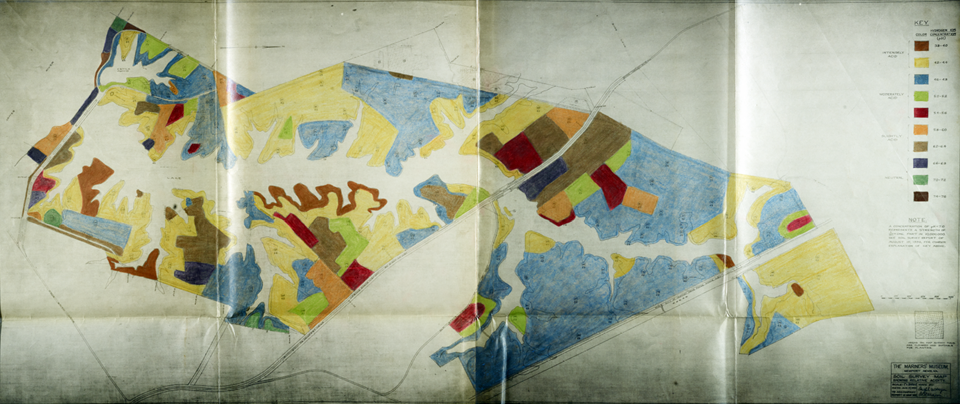
This survey did an excellent job of determining basic soil texture, color, and pH. This map helped to determine suitable locations for all plantings within the Park. The Committee’s insistence on ensuring the survival of the gardens demonstrated how seriously they took their role in the completion of the Park. Although their role was brief, the diligence of the group was important to the future success of the Park.
Since the groundwork of planning the Park was complete, the focus shifted to planting. Stay tuned for the next blog on how we accomplished that!