In mid-February, we shared the amazing story of American mathematician Dr. Galdys B. West and her important contributions to modern navigation. Dr. West created the geoid, an accurate mathematical model of the earth that laid the foundation for the technology of the Global Positioning System (GPS).
Today we are continuing this mini-series featuring women who shaped the world. Let’s go back in time and learn more about the mathematician and “Jane of all trades” named Janet Taylor.
An introduction to Janet Taylor
During the Victorian period in England, a famous astronomer and mathematician named Janet Taylor (formerly Jane Ann Ionn), made her indelible mark in the male-dominated field of science and navigation. She was born May 13, 1804, in a small village in County Durham, England.
Mrs. Taylor was well known as a mathematical prodigy early in her life. Her father played a major role in her early education. He encouraged and supported her to develop her math skills in advanced schooling, something uncommon for young women of the time.
Historians refer to her as a “Jane of all trades” due to her numerous and successful career paths including mathematician, astronomer, educator, expert navigator, businesswoman (she had two nautical academies), and instrument creator, to name a few.
One of many important discoveries she made in her lifetime was her revelation about the shape of earth. According to Putnam (2019), Mrs. Taylor developed her corrected mathematical model of earth when looking at fruit. She realized the earth is not spherical, but spheroidal (meaning the planet is slightly elongated at the poles).
So, what’s the difference between a sphere and spheroid and why does that matter in navigation? A sphere, as the earth was previously thought to be, is perfectly rounded. Earth, however, is not so mathematically perfect. Today, we know earth as an “oblate spheroid” where the middle is fatter than the poles. Similar to the imperfect, bumpy fruits, Mrs. Taylor realized the earth was also not perfectly spherical. This discovery meant navigational instruments could be corrected and improved to make travel safer and more accurate.
Thought bubble: Why was this updated model of earth so important?
Imagine sea travel in the 16th and 17th centuries. Despite routine travel on waterways, the tools many navigators and mariners utilized were inaccurate. Why? It likely goes back to how people viewed the shape of earth before Mrs. Taylor’s discovery. Let’s take a brief look back into some of the models of earth that came before Mrs. Taylor, and how it connects to accurate navigation.
Well over 2,000 years ago during ancient Greek civilizations, people understood the earth was round. Eratosthenes, an ancient Greek mathematician, even measured earth’s circumference with high accuracy. Eratosthenes measured the earth’s circumference to be about 40,000 km with basic technology and known measurements of earth at the time. In the 20th century with satellites and advanced technology, we now know earth’s circumference to be 40,030.2 km. Wow– great job Erathenes!
And yes, the infamous mariners during the Age of Discovery (about 150 years between the mid-15th century to the 17th century), and well before this, already knew the earth was round.
A unique replica in our Museum’s collection is called the Behaim Globe. This globe, created around the Age of Discovery allows us to peer into the past and understand how Europeans viewed the shape of earth.
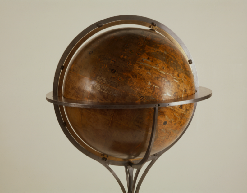
The Behaim’s globe is known as the first terrestrial globe that made a point to represent the earth as a sphere. It was created in present-day Nuremberg, Germany, by Martin Behaim in 1492. The map itself is wholly inaccurate, only containing three misshapen continents (Europe, Africa, and Asia), but the spherical shape is more important to our story.
The Behaim’s globe was created around the time when navigators used instruments like the backstaff and quadrant for sea travel. However, as many mariners discovered through disastrous consequences as sea travel increased, a spherical planet wasn’t enough mathematical information for accurate and safe navigation.
When Mrs. Taylor made the discovery of a spheroidal earth, this changed how people navigated for the better. Mrs. Taylor corrected locations at sea and recalibrated instruments. She also taught this new principle and other updated navigational concepts to her students through her maritime academies and her texts. Without this updated understanding of earth, mariners would have continued to needlessly perish at sea due to poor navigation. (Thought bubble ended)
The Mistress of Science
It’s clear that Mrs. Taylor was a “Jane of all trades” and was entrenched in navigation as an educator, master navigator, inventor, and even worked to improve and correct navigational instruments. She created a new tool called the Mariner’s Calculator.
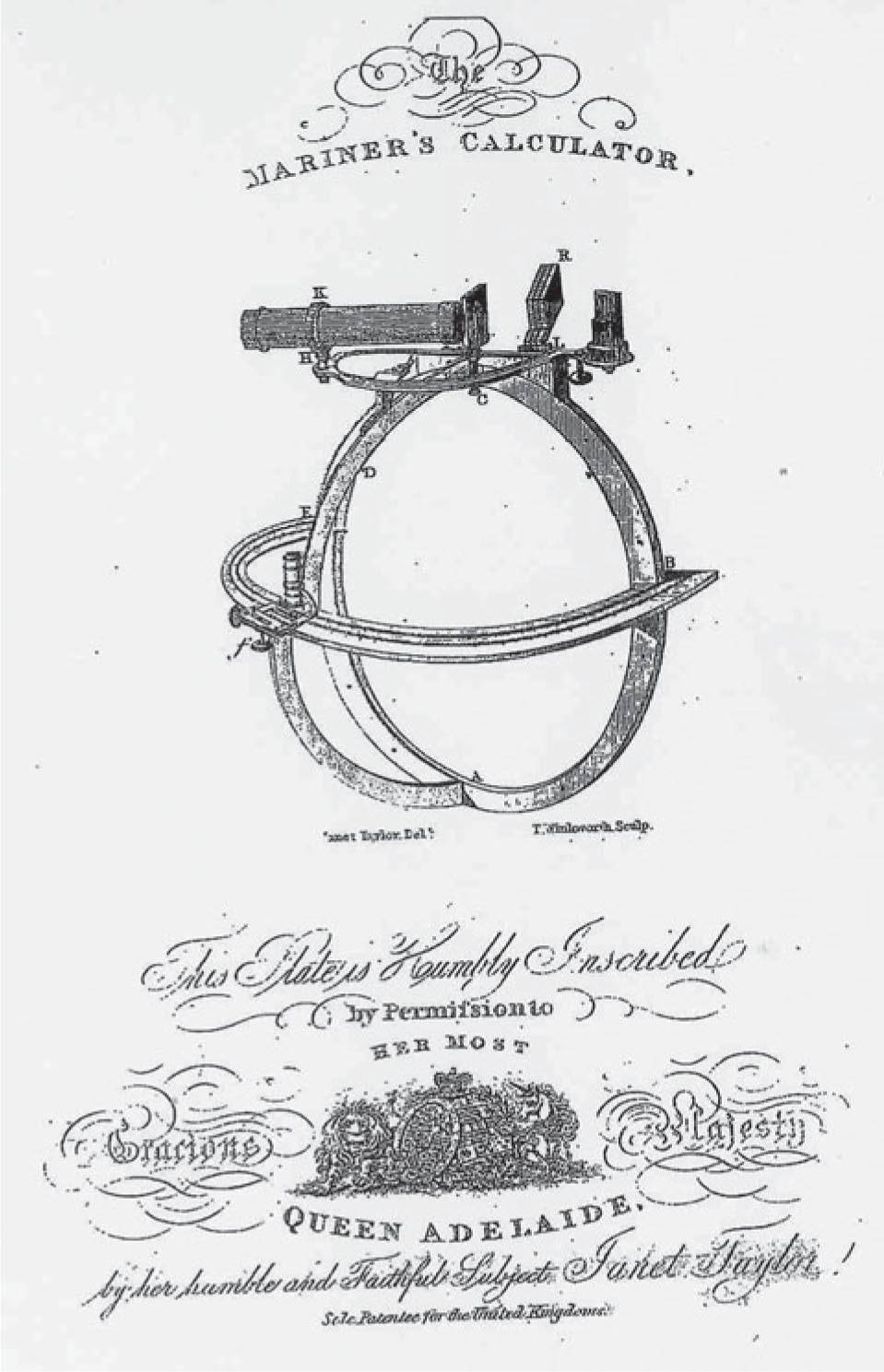
Mrs. Taylor believed the Mariners Calculator would make other instruments obsolete, as it combined a few different instruments into one. In 1834 she received a patent for the Mariners Calculator, but Admirality, the department that directed the Royal Navy at the time, deemed it unnecessary for sailors, and assumed they wouldn’t be smart enough to use it. Mrs. Taylor spent her life and money trying to promote the instrument, but did not succeed. There was only one Mariner’s Calculator made, since it did not gain popularity. Historians John and Rosilind Croucher, who co-wrote Janet Taylor’s biography, Mistress of Science, had a replica created to preserve her ingenious instrument.
(To learn more about the details into the fairness of the assessment from Admiralty and the work of John and Rosilind Croucher to get the Mariners Calculator reassessed, please read her biography and other resources listed at the end of this blog.)
Mrs. Taylor did not let this stop her involvement in the field of navigation. If we just focus on her skills as a master navigator and instrument maker, she created and improved many tools, such as octants, sextants, and compasses.
As iron became an increasingly popular building material for ships, Mrs. Taylor ensured navigational tools could function on those iron ships. Why does this matter? Iron is magnetic. A magnetic compass, for example, has a small magnet inside the instrument that picks up earth’s magnetic field. Iron can easily interfere with the effectiveness of a magnetic compass, but Mrs. Taylor worked to make sure her instruments on ships with iron did not fail.
Mrs. Taylor did a lifetime of important and valuable work (all of which is not even remotely covered here). Though time may have forgotten her story, institutions of the time did agree that Mrs. Taylor’s contributions, discoveries, and innovations were invaluable to navigation and greatly advanced England during the Industrial Revolution.
For more reading about Janet Taylor, here are some further reading suggestions:
- Mistress of Science: The Story of the remarkable Janet Taylor Pioneer of sea and navigation by: John S. Croucher and Rosalind R. Croucher
- Jane of all trades: Janet Taylor’s contributions to Victorian navigation by: Marlee Love Putnam