The Mariners’ Library is pleased to announce the addition of a significant map of Virginia to the cartographic collection. Titled New Map of Virginia compiled from the latest maps 1861, this pocket map was published in mid-1861 by the Richmond, Virginia firm of J. W. Randolph. Other Richmond area firms involved in the printing of the map include Husted & Nenning, credited with drawing and coloring it, and Hoyer and Ludwig, credited as the lithographers. Scholars consider this map a rare Confederate imprint, with fewer than ten known examples in libraries and museums throughout the United States.

The map depicts Virginia on the eve of the Civil War, with the counties that would eventually form West Virginia still shown as part of the Commonwealth. A more precise dating of the map indicates that it
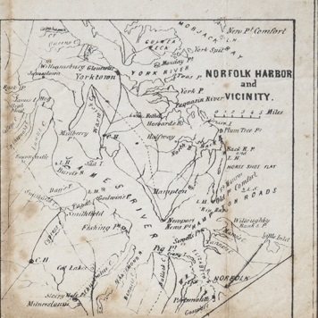
must have been printed after April 1861, as it includes Bland County, which was formed from portions of Giles, Tazewell, and Wythe Counties by an act of the General Assembly on March 30, 1861. In addition, the map includes insets in the upper right corner of the areas around Harpers Ferry and Norfolk Harbor and vicinity.
The map was the property of William Henry Irby, who served as a private in Co. G, 53rd Virginia Infantry Regiment from his enlistment in April 1862 until his capture and imprisonment as a prisoner of war in April 1865. The descendants of William Irby donated this map to the library so as to preserve it and the memories of his service during the Civil War.
Next blog: William H. Irby and the Civil War
Suggestions for further reading: Wooldridge, William C. Mapping Virginia From the Age of Exploration to the Civil War. Charlottesville and London: University of Virginia Press, 2012.