“THE CLIMATE CRISIS.” A phrase that seems to bombard us from all sides these days continually. I don’t know if “the climate crisis” is real or not; I just know that the earth has an atmosphere that seems elastic and is constantly changing and rearranging. Hot. Cold. Rainy. Dry. Maybe humans are causing a problem. Maybe they aren’t. After stumbling across several eighteenth-century vue optiques1 showing floods in three European countries that all occurred in late February 1784, I learned that sometimes the earth creates its own climate problems.

A quick internet search revealed that the three cities depicted in the engravings weren’t the only locations affected by wintertime flooding. Floods had occurred on rivers throughout northern France, the Netherlands, Spain, Poland, Belgium, Luxemburg, Hungary, Slovakia, and Slovenia. Because all the flooding events had occurred simultaneously on different rivers in cities that were sometimes hundreds of miles apart, I became very curious about exactly what had caused such widespread devastation. As it turned out, wintertime flooding in Europe wasn’t the only weather-related disaster occurring in 1783 and 1784. Climate-related problems were happening over much of the world.
The problems started when a weird fog or haze descended over most of the Northern Hemisphere in the summer of 1783. The strange fog ushered in a period of abnormally high summertime temperatures accompanied by horrifying electrical storms over much of Europe, Scandinavia, and England. That year and the next, severe droughts or low temperatures combined with excessive rain caused crop failures and famine in Africa, India, China, and Japan2. At the same time, people in North America, Asia, and the Arctic were suffering through an abnormally cold summer followed by an extremely severe winter. In February 1784, the Chesapeake Bay froze all the way to its mouth. The Mississippi River also froze over – even in New Orleans! Surprised mariners reported seeing large blocks of ice floating a hundred miles offshore in the Gulf of Mexico!3 Can you even imagine such a thing?

So what the heck caused the fog and the climate crisis that followed? One word: volcano.
It all started in southeastern Iceland when the 16.8-mile-long volcanic fissure called Lakagígar4 and the volcano from which the fissure extends, Grímsvötn, began erupting on June 8, 1783. The eruption wasn’t exceptionally explosive, but the location, nature, and length of the Laki event made it one of the most impactful volcanic eruptions in world history. The Lakagígar fissure ejected gas, lava, and volcanic debris into the atmosphere for eight months. The fissure finally stopped erupting on February 7, 1784, while Grímsvötn continued erupting through May 1785.
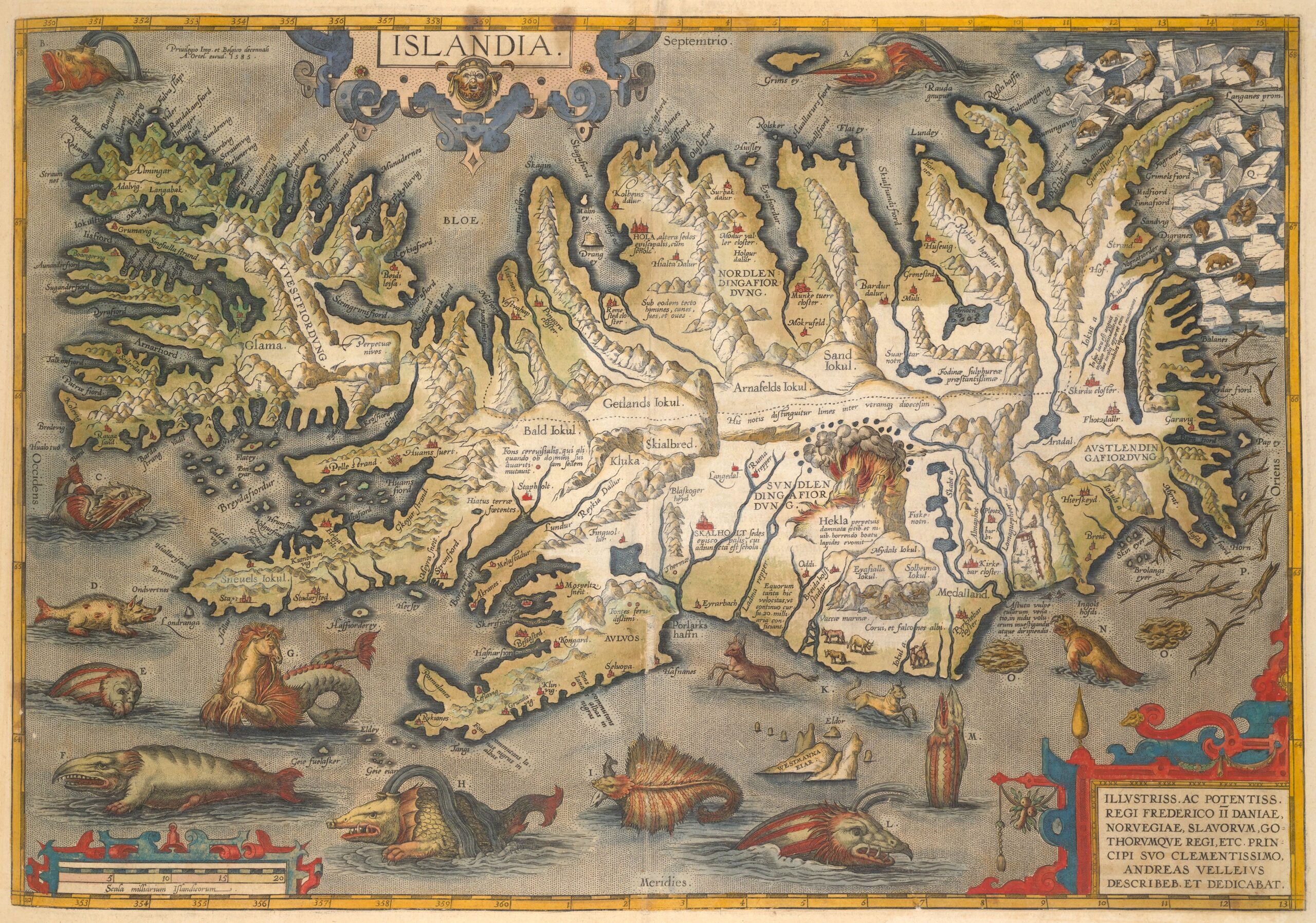

As I mentioned, the initial eruption wasn’t explosive (nothing like the January 2022 Tonga5 eruption), but scientists estimate that lava fountains along the fissure reached 2,600 to 4,600 feet in height. The eruption column (the massive, roiling cloud of superheated ash, gas, and other materials that rises from the volcano) extended 5.5 to 9 miles into the atmosphere (depending upon which point within the eruption cycle you’re looking at). Since the lava flows and floods tended to follow river beds and existing gorges, relatively few structures were destroyed, and few lives were lost.

What was exceptional about the eruption was the massive volume of material that spewed out of the Laki fissure:
- Approximately 42 billion tons of lava (14.7km3). That’s enough to bury Manhattan island under 820 feet of lava.
- The volume of “pyroclastic fall” (i.e., the material ejected from the volcano that fell back down to earth and coated nearly all of Iceland and some of Europe) was about 1.2 billion tons (if my math is right). That’s double the amount of material ejected from Mount St. Helens in 1980.
- The gasses released into the atmosphere included 122 megatons of sulfur dioxide (SO2), 235 megatons of water (H2O), 15 megatons of Chlorine (Cl), and more than 7 megatons of Fluorine (Fl). One megaton equals one million tons of TNT, which means Laki released 122,000,000 tons of sulfur dioxide into the atmosphere! As a matter of comparison, the EPA says that in 2021, all of the coal-fired power plants in the United States only released .94 (POINT nine four!) million tons of SO2. Those plants could run nearly 130 years before releasing the same amount of sulfur dioxide as the Laki fissure! If you compare the eruption with another volcano, Mount Pinatubo in the Philippines released just 20 megatons of sulfur dioxide during its 1991 eruption.

As you would expect, the ejection of all this material into the atmosphere was catastrophic. The layer of poisonous ash deposited over most of Iceland decimated plant, animal, and aquatic life. Livestock grazing on polluted grasslands and people ingesting contaminated food and water quickly began exhibiting the horrifying effects of fluorine poisoning (called fluorosis6). The sulfur dioxide also reacted with atmospheric moisture and then rained down as sulfuric acid strong enough to burn holes in leaves and cause wounds on the skin of animals and people.
Eventually, the poisons killed most of Iceland’s livestock7. Over the year of the eruption and the few years that followed, about a quarter of Iceland’s population died from fluorosis and famine. The situation was bad enough that the king of Denmark, who ruled over Iceland then, considered evacuating the surviving residents from the country.

Iceland wasn’t the only place affected by the eruption. The polar jet stream caught the gasses and other materials that spewed into all levels of the atmosphere and spread across the entire Northern Hemisphere. In June 1783, a phenomenon now known as the “Laki haze,” a reddish to bluish dry or hot fog that smelled strongly of sulfur, descended over most of Europe and the Baltic region (it even reached parts of North America). Besides affecting people’s health7, the haze severely affected the climate in certain parts of the world. Summers were hotter than normal in some places (the haze caused a greenhouse-type effect) and colder than normal in others, but the winter following the eruption seems to have kicked everyone’s butt.

The long-lasting winter of 1783-1784 was characterized by severely low temperatures for prolonged periods that froze soils and waterways and caused heavy accumulations of snow. Depending upon a town’s elevation, it may have had anywhere from 15 to 275 inches of snow on the ground. In late February, Würzburg, Germany, reportedly had nearly six feet of snow on the ground, while the Vltava River at Prague was sealed by a layer of ice more than 46 inches thick!

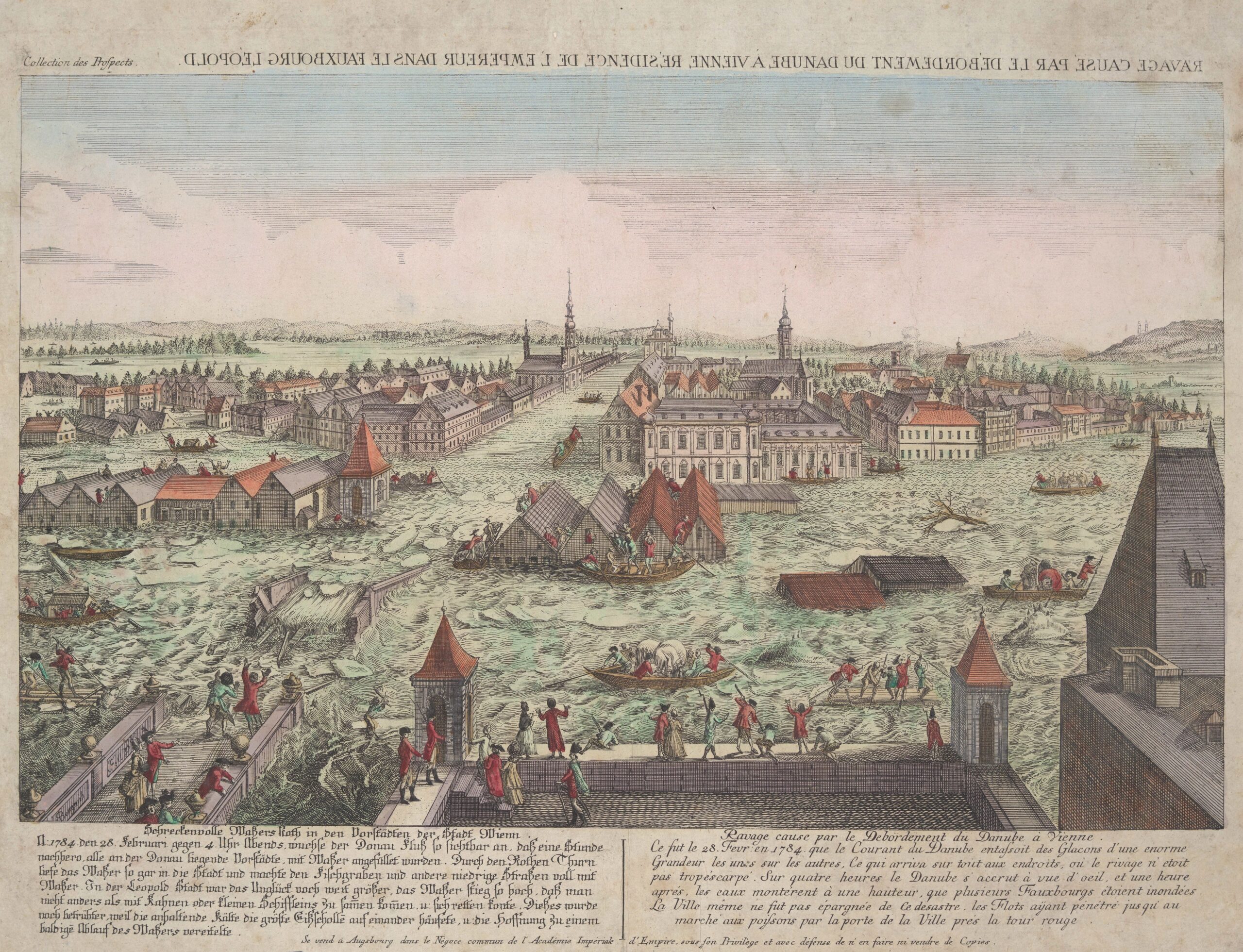
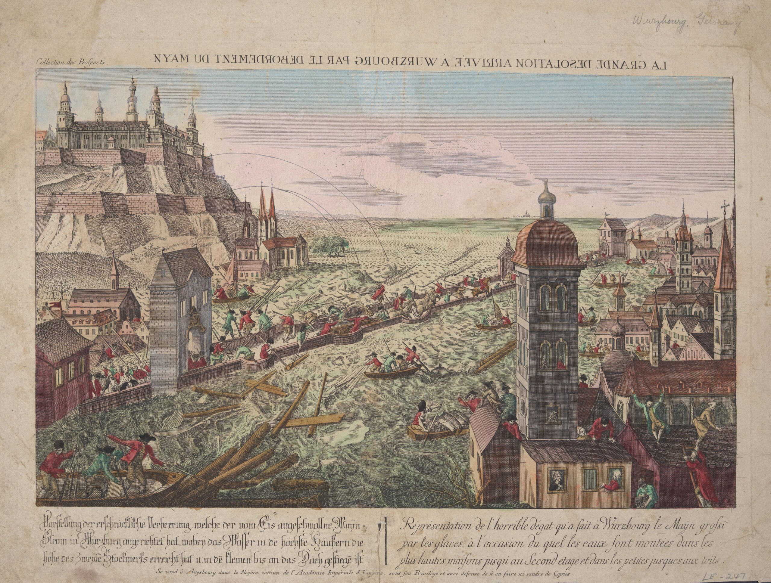
While flooding events happened several times over the winter, the most devastating occurred in France and Western/Central Europe in late February and early March. This is the area and time period depicted in our engravings which show the flooding of the Vltava River at Prague, the Danube River at Leopoldstadt in Vienna, and the Main River at Würzburg.
It all started at the end of February when a sudden warm-up combined with heavy rainfall caused a rapid snowmelt and break-up of the river ice. According to bridge historian Bernd Nebel, the thawing snow formed massive torrents of water that headed for Europe’s rivers. As the meltwater worked its way under the river ice, the pressure increased to such an extent that the ice was eventually blown apart from underneath. The result was massive floods filled with blocks of ice that swept away everything in their path – residences, mills, churches, trees, ships, animals, and people. Frequently the ice and flotsam heading down the rivers wedged in shallow or constricted locations or was trapped by bridges and created massive ice jams. These impromptu dams caused a rapid and deep build-up of icy water that inundated cities and trapped people in (or on!) their homes for several days.


In many cities, people frantically worked to break up the jams so the ice would continue moving downriver and relieve the flooding, but the volume of water and ice in most locations was simply too great. Sometimes the pressure of the water caused natural jams to burst, sending a sudden massive and inescapable rush of water, ice, and flotsam downstream. Where ice jams were created by bridges, only the sturdiest structures survived the massive build-up of pressure behind the jam.

A report in the Austrian newspaper Wiener Zeitung dated March 3, 1784, provides an account of the flooding on the Danube River around Vienna:
…on the 28th [February] at noon [ice] broke up above the village of Nussdorf and started to move. On the morning of the 29th, the ice in the Danube arm nearest to Vienna also gained some momentum, but at first it was jammed at the first Danube bridge next to the Augarten. There were workers there who were breaking up the ice floes to make them pass through more easily. At noon, the workers were suddenly shooed away from work, as the Danube set itself in motion with a mighty gush. In its course, it rolled mighty ice floes on top of each other on both sides of the bank, where it was not really steep and very high, and formed a new extended shore […]
Still sadder was the situation of the inhabitants in Leopoldstadt, where all houses along the bank were filled with water. The level of the water increased at many places to three feet so that one could not get [in any] other way from one place to another [except] by boat. It still rose the following night considerably and what made this sad situation far worse was the persistent cold weather, removing the hope of a rapid breaking up of the ice on the Danube River and increasing the misery thoroughly.

In Würzburg, the Old Main Bridge created a huge flotsam-filled ice jam. Cannonballs were fired from the Marienburg Fortress into the field of ice above the bridge in an effort to break up the ice and relieve the flooding, but they had no effect. Men stood on the old stone bridge, feverishly working to push ice blocks, trees, and other debris under the bridge with long poles. Bombs were kept at the ready in case the ice showed any sign of freezing against the bridge. According to the newspaper Regensburg Zeitung, the water rose so quickly that within a few hours, more than half of Würzburg was underwater. While many houses had been evacuated, many had not, and the people in those had to be rescued by boat or remained trapped in their homes, sustained by food deliveries. Sadly, the very low water temperature made it nearly impossible for anyone overtaken by the icy water to survive.
For many cities on the Danube and its tributaries and in many parts of central Europe, the flood is still considered the most disastrous flooding event to have occurred in the last millennium. Scientists believe the Laki eruption may have caused the average temperature to drop for at least five years. Besides causing poor harvests, Europeans continued to suffer from severely cold winters. Luckily, the floods of 1783 and 1784 did not repeat themselves. Worldwide, it’s estimated that as many as six to eight million people died as a result of the climate changes caused by the Laki eruption. That’s one serious climate crisis I pray never repeats itself, but the planet is constantly changing and rearranging itself, so I don’t think it’s a wish that will be granted. What I do believe is that human ingenuity is an amazing thing, and if we learn from the lessons of past events, we can develop tools and plans to prevent such a huge loss of life in the future.

End Notes
1 The vue optique is a print that was popular in Europe in the 18th century. The prints were viewed through an “optical machine” or “zograscope” which gave the scenes depicted the illusion of depth. Unlike today, where images of far off places or events reach us instantaneously, the vue optique was one of the only ways people could see foreign countries or understand events that happened around the world.
2 The most severe famine in Japan’s history occurred in the summer of 1783. It was caused by unusually low late-summer temperatures and excessive rainfall which combined to destroy the rice harvest. By January of 1785 nearly a sixth of Egypt’s population had died or left the country after dry conditions stopped the annual flooding of the Nile causing crop failures. India’s Chalisa Famine of 1783-1784 combined with a famine that occurred the year before are estimated to have killed about 11 million people.
3 Page 78 of Vue de la colonie espagnole du Mississipi, ou des provinces de Louisiane et Floride Occidentale : en l’année 1802. Edited by Berquin-Duvallon and published in Paris in 1803.
4 Lakagígar is usually shortened to “Laki” while the Icelandic peoples refers to the event as the “Skaftár-fires.”
5 Tonga is in the South Pacific and its January 2022 eruption was exceptionally explosive. Here’s a great video of the explosion as seen from space: https://www.jpl.nasa.gov/news/tonga-eruption-blasted-unprecedented-amount-of-water-into-stratosphere
6 The effects of fluorine poisoning are horrifying. They include: shedding skin, moulting of hair, the growth of hard, swollen lumps in joints, swelling of the head, corroding of the intestines which causes hemorrhages, unexplained growths, fragile bones, animal’s tails and hooves falling off, and severe bone and tooth formations just to name a few.
7 Clive Oppenheimer’s book Eruptions that Shook the World says that 50% of all the cattle, 79% of the sheep, and 76% of the horses died between 1783 and 1785.
8 The haze was highly toxic and burned the eyes and throat. It severely affected people prone to respiratory problems or with heart ailments and eventually tens of thousands of people across England and Europe died from haze-related health problems.
Want to learn more? Tons of research has been conducted on the Laki eruption and its effects. Here are a few of my favorites.
Articles:
Atmospheric and environmental effects of the 1783–1784 Laki eruption: A review and reassessment. By Thorvaldur Thordarson and Stephen Self. Available at: https://agupubs.onlinelibrary.wiley.com/doi/epdf/10.1029/2001JD002042
Ice Jams and their Impact on Urban Communities from a Long-term Perspective (Middle Ages to the 19th Century) by Christian Rohr. Available at: https://www.degruyter.com/document/doi/10.1515/9783110677065-012/html
European floods during the winter 1783/1784: scenarios of an extreme event during the ‘Little Ice Age’ by Rudolf Brázdil & Gaston R. Demarée & Mathias Deutsch & Emmanuel Garnier & Andrea Kiss & Jürg Luterbacher & Neil Macdonald & Christian Rohr & Petr Dobrovolný & Petr Kolář & Kateřina Chromá. Available at: https://www.researchgate.net/publication/225352675_European_floods_during_the_winter_17831784_Scenarios_of_an_extreme_event_during_the_’Little_Ice_Age‘
Book:
Island on Fire, by Alexandra Witze & Jeff Kanipe. New York: Pegasus Books, Ltd., 2014.